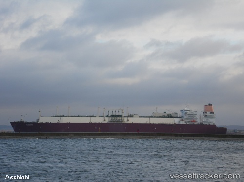
vessel Al Nuaman IMO: 9431135, Lng Tanker
vesseltracker.com
Vessel Al Nuaman IMO: 9431135, Lng Tanker
MMSI: 538003351 callsign: V7QF7 size: 315x50

Find the position of the vessel Al Nuaman on the map. The latter are known coordinates and path.

marine traffic ship tracker show on live map

The current position of vessel Al Nuaman is 13.4143 lat / 68.6113 lng. Updated: 2025-05-09 15:34:38 UTC

Currently sailing under the flag of Marshall Is

Al Nuaman built in 2009 year

Deadweight:
121910 t

Gross tonnage:
136980
Service entry:
2009-01-01T00:00:00Z

Manufacturer:
Hanwha Ocean (shipbuilder of South Korea)
Details:


Last coordinates of the vessel:
UTC, 13.9084, 68.1394, course: 137, speed: 16
UTC, 13.7208, 68.3452, course: 130, speed: 15.9
UTC, 13.6699, 68.3897, course: 137, speed: 15.9
2025-05-09 15:34:38 UTC, 13.4143, 68.6113, course: 137, speed: 16.4

Track of the vessel in the last 14 days


The ship also appears on the maps:


Most frequent ports a vessels calls at Al Nuaman (538003351):

Sambu, traffic: 22
Singapore, traffic: 11
Bur Ibrahim, traffic: 9
Mutrah, traffic: 7
TANAH MERAH, traffic: 6
RAS LAFFAN, traffic: 5
Port Said, traffic: 4
BATU AMPAR, traffic: 4
PENGERANG, traffic: 4
Strait Of Gibraltar, traffic: 4
Map Ta Phut, traffic: 3
Ra’S Shukhayr, traffic: 3
BUKOM ISLAND, traffic: 3
Mina Saud, traffic: 2
PULAU SAMBU, traffic: 2

Link to the map:


Find another ship

Al_Nuaman (538003351) last ports (portcalls and passsages)

Fateh Terminal | 2025-05-06 10:49:14
RAS LAFFAN | 2025-05-04 21:06:45
PORT QASIM | 2025-04-25 03:22:28
RAS LAFFAN | 2025-04-20 04:05:13
BUKOM ISLAND | 2025-04-09 06:49:45
TANAH MERAH | 2025-04-09 05:40:21
PENGERANG | 2025-04-09 04:23:45
Map Ta Phut | 2025-04-06 06:12:13
PENGERANG | 2025-03-29 07:20:56
TANAH MERAH | 2025-03-29 06:16:06
Sambu | 2025-03-29 05:18:19
RAS LAFFAN | 2025-03-18 08:20:16
TANAH MERAH | 2025-03-03 00:37:00
DONGJIAKOU | 2025-02-23 02:05:57
PENGERANG | 2025-02-09 19:13:41
BATU AMPAR | 2025-02-09 18:29:21
BUKOM ISLAND | 2025-02-08 23:20:40
RAS LAFFAN | 2025-01-27 20:43:45
SULTAN QABOOS | 2025-01-25 06:09:07
BUKOM ISLAND | 2025-01-17 03:57:25
BATU AMPAR | 2025-01-17 02:56:31
PENGERANG | 2025-01-17 02:14:51
Map Ta Phut | 2025-01-13 22:38:25
TANAH MERAH | 2025-01-10 17:16:46
RAS LAFFAN | 2024-12-30 17:28:20
Strait Of Gibraltar | 2024-11-29 03:26:10
TANGER MED | 2024-11-29 02:36:36
CARTEYA GUADARRANQUE | 2024-11-28 13:19:24
TANGER MED | 2024-11-15 00:27:36
Strait Of Gibraltar | 2024-11-15 00:08:11
Sambu | 2024-07-18 06:49:58
Sambu | 2024-07-08 05:28:03
Mina Saud | 2024-06-20 03:17:31
Swinoujscie | 2024-05-10 07:25:04
Korsor | 2024-05-09 10:45:14
Skagens Odde | 2024-05-08 02:11:38
Yokohama | 2023-12-24 04:58:24
Yokosuka | 2023-12-22 22:27:02
Singapore | 2023-12-15 03:23:17
Singapore | 2023-11-15 05:53:20
Sambu | 2023-11-15 04:58:12
Map Ta Phut | 2023-11-11 23:34:18
Sambu | 2023-11-09 12:16:31
Singapore | 2023-09-24 18:39:05
Kaohsiung | 2023-09-12 23:22:17
Sambu | 2023-09-04 14:03:05
Singapore | 2023-08-10 04:41:13
Sambu | 2023-08-10 04:09:48
Sambu | 2023-07-21 10:27:14
Sambu | 2023-06-28 23:30:33
Bur Ibrahim | 2023-05-25 17:33:07
Port Said | 2023-05-25 07:52:46
Dover | 2023-05-16 11:04:17
Zeebrugge | 2023-05-14 22:32:13
Strait Of Gibraltar | 2023-05-10 17:45:38
Port Said | 2023-04-29 14:12:38
Bur Ibrahim | 2023-04-29 03:40:16
Ra’S Shukhayr | 2023-03-08 23:49:05
Bur Ibrahim | 2023-02-15 05:08:12
Ras Gharib | 2023-01-22 20:29:01
Bur Ibrahim | 2023-01-22 14:19:33
Bur Ibrahim | 2023-01-08 06:03:41
Mina Saud | 2022-10-04 22:20:37
Bur Ibrahim | 2022-09-22 13:41:02
Swinoujscie | 2022-09-09 07:25:47
Korsor | 2022-09-07 07:47:15
Strait Of Gibraltar | 2022-09-01 00:19:54
Bur Ibrahim | 2022-08-22 04:45:26
Ra’S Shukhayr | 2022-08-21 10:18:03
Ra’S Shukhayr | 2022-04-12 00:25:03
Port Said | 2022-04-11 06:45:21
Bur Ibrahim | 2022-04-02 06:55:03
Mutrah | 2022-03-09 06:59:50
Sambu | 2022-02-28 21:50:55
Sambu | 2022-02-28 21:05:15
Sambu | 2022-02-20 03:40:40
Mutrah | 2022-01-25 22:24:36
Singapore | 2022-01-17 10:05:23
Sambu | 2022-01-06 02:40:06
Mutrah | 2021-12-14 13:29:09